"Unofficial" Trailhead
View from the trail above entry point
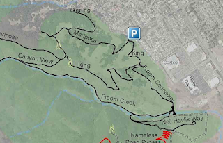
This is an unofficial trailhead, and a quick and easy way to tie into the Froom Ranch Trail, which otherwise would have to be accessed at Madonna Road or from the Johnson Ranch Trail connector [a 5 mile hike]. Our plan was to hike Froom Ranch to the King Trail, up to the Canyon View Trail, down to the Froom Ranch and back around to the COSTCO entry for a round trip of 2.9 miles:
CCCMB.ORG map
Trail highlighted
Prior to starting, I checked my gear over and clipped the zippers on my pack closed using little carabiner snaps. If you've done any hiking with a pack, you may've experienced having the zipper work their way open, or worse, losing gear along the trail. This will help prevent that from occurring:
Clip your zipper pulls shut
Tom likes to make hikes into a training and conditioning opportunity, so he wore his snake gaiters. Don't laugh! A Ventura SAR member was snake bit a few years ago and the medical care cost 1 million dollars and 70 vials of anti-venin!
Mike leads the way.
Please notice the snakebite gaiters
As we ascended the Froom Ranch Trail to the King Trail, a gentle, cool breeze stirred occasionally, cooling us off. There were also shady groves of oaks of cool greenery to rest in:
Crazy Cool
As we passed over a footbridge into the oak woodland I heard Tom call out, "Snake" and saw him come to a stop. I came forward and saw a large adult rattlesnake resting on the hillside next to the trail, beneath an oak:
Pacific Rattlesnake
Pit Viper with heat-sensory head organs
Rattles. They get a new bead every time
They shed their skin.
The Rattlesnake was very content to lie there and didn't even bother to rattle. We wished him well and passed on and continued our hike, warning to City Rangers we encountered. just up the trail. The wildflowers were blooming and were gorgeous:
Nature's beauty
On top of the King Trail atop the ridge, we were treated to a nice view of San Luis Obispo's trademark peaks, the Morro's:
[L-R] Cerro Romauldo, Chumash, Bishop, and
Cerro San Luis [Madonna Mountain]
As we enjoyed the view, Tom took the opportunity to check his GPS device and benchmark our location as he mapped the route. The route we followed is one of 3 stepped fitness and conditioning courses [the other 2 are on Cerro Alta Trail near Atascadero] and requires team members to carry a #25 pack load:
Checking GPS
We moved on, dropping down the Canyon View Trail and tying back into the Froom Canyon Trail. The hike down the canyon was rocky and sun exposed. At this point we were both starting to hit our canteens often:
Froom Trail, looking back up the canyon
There were some unique gnarled dried, wood pieces along the trail:
Desert Wood
Tom called out that he could hear water running, and presently, he pointed out two streams trickling down the canyon wall opposite of us. I wondered if they might be supplied by a spring on top of the ridge?
Water!
The water reaches the stream bed in the
Canyon bottom
The hike was done at a leisurely pace with plenty of stops to observe nature and listen. It took us about 2:20:00 to cover the nearly three mile course [Sheriff's Search & rescue allows 3 hours to complete the course], and would be a great short hike for anyone. Of course, always carry water, wear sunscreen and a hat, and keep your cellphone handy. If you are visiting the San Luis Obispo are and want to hike our local trails, drop me a message and I will connect you with some links for download trail maps. Also, check out my FACEBOOK page [Bushcraft Woods devil] for interesting hiking & camping tips and links.
Goblin Ranger
[AKA "Bushcraft Woods Devil"]
Happy Hiking!
GOBLIN RANGER


No comments:
Post a Comment